5/15
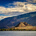
Turtle Rock Island near Lincoln Rock State Park. Originally a simple rocky hill on the south bank of the Columbia River, US Highway 2 ran through it. The construction of the Rocky Reach Dam in 1960 caused the formation of Lake Entiat around this hill, cutting it off from the rest of the south bank, submerging the old US Highway 2, and creating Turtle Rock Island. It is now a protected wildlife area accessible only by boat.
- Author
- matthucke
- Created on
- Saturday 10 June 2017
- Posted on
- Saturday 17 June 2017
- Albums
- Visits
- 20855
- Rating score
- no rating
- Rate this photo


4 comments
Add a comment